Thursday, March 20, 2014

1964 Earthquake Online Resources

by Karen Brewster

With March 27 being the 50th anniversary of the Great Alaska Earthquake of 1964, check out these websites that have historical material about the quake. There is information of interest to students, teachers, journalists, historians, and the general public.

Great Alaska Earthquake of 1964, Historical Research Portal, Archives and Special Collections, Consortium Library, University of Alaska Anchorage (http://www.64akquake.org/about/)
With the website, UAA’s library provides a single location for researchers looking for primary source material about the earthquake, including photographs, books, documents, and oral histories. It represents a variety of libraries, archives, museums and other organizations around Alaska that have earthquake material in their holdings.

The Great Alaska Earthquake of 1964, Alaska Earthquake Information Center (AEIC) (http://www.aeic.alaska.edu/quakes/Alaska_1964_earthquake.html)
This is part of larger website of the Alaska Earthquake Information Center, Geophysical Institute, University of Alaska Fairbanks. It contains general information and description of events related to the 1964 earthquake and the tsunami that followed.

50th Anniversary of the 1964 Earthquake, State of Alaska, Division of Homeland Security and Emergency Management (http://ready.alaska.gov/64quake)
This website provides historical information, photos and videos about the 1964 earthquake and anniversary events. It also provides useful links to other resources.

Alaska Earthquake Alliance (http://alaskaquakealliance.org/index.php)

This website provides scientific information about earthquakes and earthquake preparedness. It also contains film footage of the 1964 earthquake. The Alaska Earthquake Alliance is composed of member groups and organizations, and coordinates earthquake awareness and preparedness activities in Alaska. The Alliance is a part of a statewide alliance linking organizations and individuals that provide earthquake information, services, and who desire to improve on earthquake preparedness and awareness.

Saturday, March 15, 2014

Personal Memories of a Statewide Disaster: Ouzinkie in 1964

by Anjuli Grantham
Earl and Merrle Carpenter lived in Ouzinkie
in 1963 and 1964. (Baranov Museum/
Kodiak Historical Society, P-914-38)

After living through the undulations of March 27, 1964, Kodiak elder Iver Malutin measures earthquakes based on the amount of water that slops from a full glass. For years, a local basket weaver subconsciously made sure there was an escape route from beaches where her family played. Another elder recalls the infernal heat blaring on the inside of the Navy plane that evacuated her and her children to Seattle a few days after tsunamis washed boats through downtown Kodiak. The history of March 27, 1964, like so many disasters, is crafted from individual stories and anecdotes. Personal stories collected and spun together give a sense of the fear, camaraderie, loss, and even moments of humor that percolated through the traumatic days following the earthquake and tsunami.

Recently, the Baranov Museum received a collection of images, ephemera, and objects that documented one couple’s Good Friday Earthquake experience. Merrle and Earl Carpenter were young Washingtonians, looking for adventure, when they responded to an ad in a 1963 Sunday newspaper, seeking a cannery storekeeper and postmaster in the village of Ouzinkie. Ouzinkie is an Alutiiq village on Spruce Island, within the Kodiak archipelago. The Carpenters sold their furniture and headed north, towards an adventure that they certainly weren't counting on.

Last year, Merrle sat down with her granddaughter and recorded her memories of surviving the ‘64 quake and tsunami in Ouzinkie. The following includes excerpts from their conversation.

Ouzinkie villagers gathered on Mount Herman as
their village was inundated by a series of
tsunamis. (Baranov Museum/
Kodiak Historical Society, P-914-8)
“'All of a sudden the stove started to move. At first I thought I was dizzy,” Merrle recalled. Yet, like the other villages around Kodiak, the shaking didn't cause much structural damage to Ouzinkie. Regardless, “'I decided to take pictures because I didn't think the boss would ever believe this. Well I started snapping pictures and unbeknownst to me I was taking pictures of the bay going dry. All the water was going out and the natives told me that I’d better get up on high ground because that water’s going to all come back, and it's going to come back fast,” Merrle said.

Merrle and Earl headed up Mount Herman with the rest of the villagers. Once above the village, Merrle snapped a photo of some of those who had gathered. What appears to be a photo of a pleasurable picnic most certainly was not.

“We had some boats that were on their way back to Kodiak Island and we were concerned about them because we could hear them on the radio, calling for help and letting us know what was happening out there. Then the radio went out and the store was under water.”

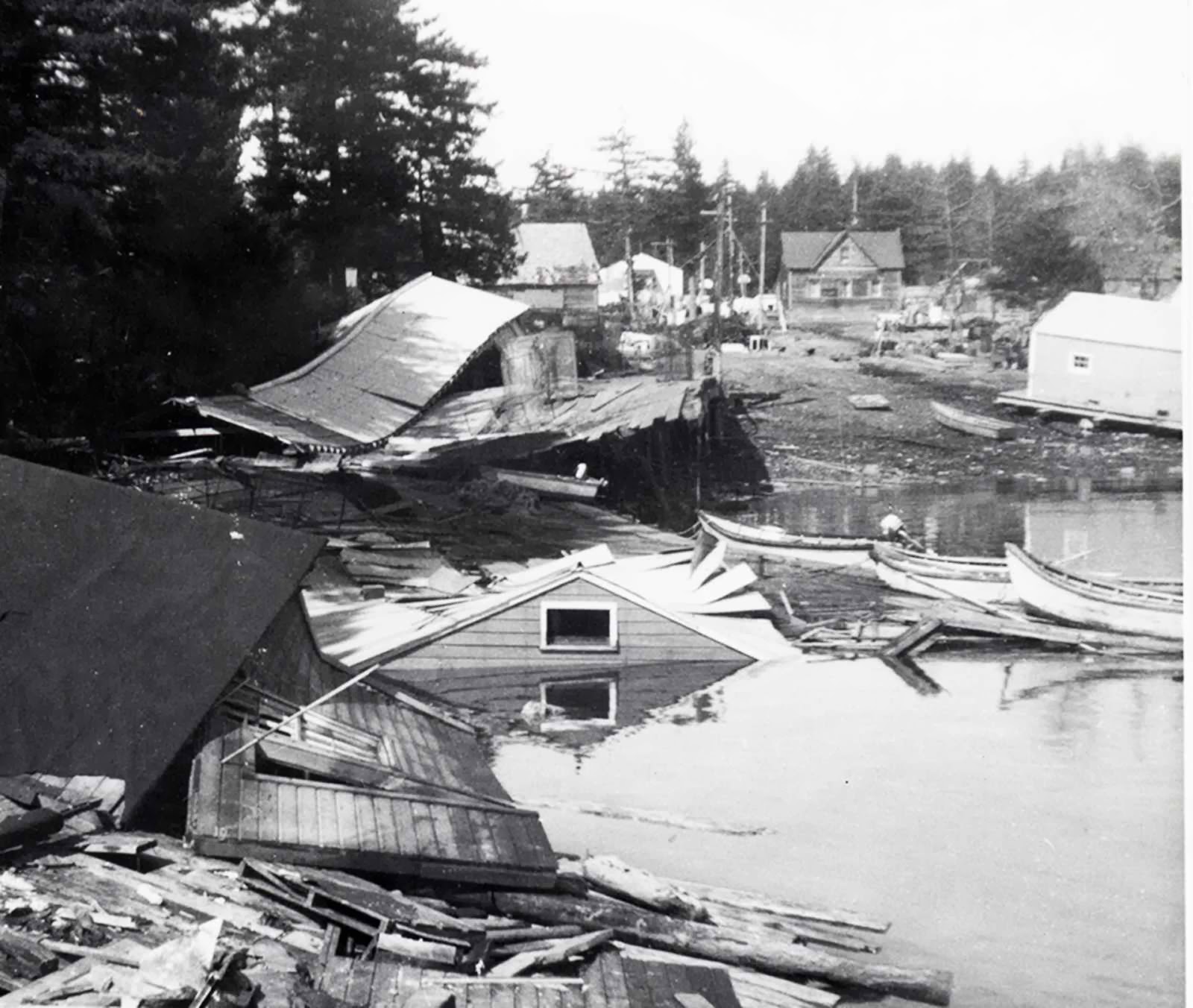
The back end of the cannery store went out to sea with
the retreating tsunami waters. Canned food held
within the front of the store (pictured above) was
salvaged to feed the community. (Baranov
Museum/ Kodiak Historical Society, P-914-9)
After a series of tsunamis had washed through the cannery, the couple ran down to the store to grab supplies and survey the damage to their workplace and home. “The back half of the store became detached from the rest of the building and was floating out in the bay.” In fact, the Ouzinkie Packing Company was nearly completely washed away and with it, the livelihood of most Ouzinkie villagers. It was never rebuilt. Merrle remembered, “The company had lost everything they had there, their whole investment. The cannery went out to sea.”

Merrle continued, “When we came down off the hill early in the morning we discovered that the store was inundated with water and practically everything in the store was wrecked... We had decided that we’d take turns watching the water because it was still high tide and if it was necessary we would get out of there.” Although aftershocks continued to rattle Ouzinkie for weeks, the seismic shaking did not spur any other tsunamis.

This $2 bill was rescued from the store’s safe and is still
covered in tsunami silt. (Baranov Museum/ Kodiak
Historical Society, 2012-21-04)

Most of the store goods were destroyed, but the canned food was unaffected. “A lot of the labels had come off of the cans so we had to guess what was in them, but we didn't care because it meant there was something to eat.” The Carpenters were also able to salvage the safe, and dry out $4000 worth of waterlogged bills on top of the stove. “So that took a little while to do and I can still feel the silt on my fingers today from that,” Merrle recalls.

Merrle and Earl stayed through the end of their contract and left Ouzinkie in May of 1964. In the months to come, Merrle received special commendations from the USPS for “the unselfish devotion to the public service that was so amply demonstrated by postal people during the disastrous earthquake” and a personal note of thanks from US Senator Bob Bartlett. These documents are now a part of the archive at the Baranov Museum/ Kodiak Historical Society.
The Ouzinkie Packing Company was demolished
and never rebuilt. (Baranov Museum / Kodiak
Historical Society, P-914-27)

The Carpenter Collection is among the collections of objects, photos, and oral histories held in trust by Alaska’s historical organizations that help to preserve the story of ordinary people who lived through the spring of 1964, an extraordinary time.

Wednesday, March 12, 2014

Valdez Museum Commemorates the Good Friday Earthquake and the Exxon Valdez Oil Spill

by Andrew Goldstein

The fifty-year anniversary of the Good Friday Earthquake, the record-breaking, 9.2-magnitude quake that necessitated the relocation of the entire town to its present site and resulted in 32 lives lost from Valdez, has prompted the Valdez Museum to work with the City of Valdez and other organizations to facilitate a series of events throughout the year.

The museum’s Remembering Old Valdez Exhibit, at 436 S. Hazelet Avenue, will be open to the public for additional hours of operation beginning on March 27. The extended season will provide extra opportunities for the public to see all that ROVE has to offer. Remembering Old Valdez features the museum’s award-winning documentary “Between the Glacier and the Sea,” telling the story of Valdez’s Gold Rush and earthquake history. The centerpiece to the attraction is a 1:20 scale model of Valdez as it appeared in 1963 – one year before the quake – accompanied by photographs and an interpretive booklet. Other highlights include a touch-screen kiosk featuring personal interviews with earthquake survivors, a furnished section of an Old Town house, and exhibits about Valdez’s firefighting history.

The Valdez Museum also commemorates another significant historical event that coincidentally occurred on a Good Friday, the Exxon Valdez Oil Spill. On March 24, 1989, the tanker Exxon Valdez collided with Bligh Reef, spilling an estimated 10.5 to 11 million gallons of crude oil into Prince William Sound. Working in concert with the Prince William Sound Regional Citizens’ Advisory Council, the museum has arranged for an RCAC presentation in Valdez classrooms on March 24 to commemorate the anniversary.

The museum is also working with PWSRCAC to build content about EVOS on its new website. It will feature as many as 20 oral histories of people impacted from the 1989 Exxon Valdez oil spill. These 20, consist of 10 previously recorded recordings from “The Spill: Personal stories from the Exxon Valdez Disaster,” as well as 10 that are newly recorded. In August, the museum will host author and former Valdez resident, Angela Day, for a book launch and signing of her latest tome, “Red Light to Starboard: Recalling the Exxon Valdez Disaster.”

March 2014 also includes the unveiling of the museum’s newest permanent upgrade, “A Moving Experience: A Look Back at the Good Friday Earthquake.” Funded in part by the City of Valdez and the Rasmuson Foundation, this upgrade to the museum’s earthquake exhibit at its main site features an all-new look at the experience of the earthquake and its effects on Valdez, featuring rarely-seen artifacts and photographs from the museum’s collection.

The summer of 2014 includes a traveling temporary exhibition. Entitled “Communities, Disaster & Change,” the exhibition provides a twist on the earthquake commemoration through its connection with other communities and other disasters. Funded in part by the Western States Arts Federation, the City of Valdez, the Rasmuson Foundation, and Alyeska Pipeline Service Co., “Communities, Disaster and Change,” features artwork in a variety of media by 28 of Alaska’s finest artists. Reacting to the theme of how artists and communities relate to their own experience with natural disasters, the exhibit will be accompanied by a full-color catalogue.

“Communities, Disaster and Change” will be on display at the Valdez Museum from May to September, 2014, before touring to Homer, Cordova, Fairbanks, Juneau, Kaneohe, Hawaii, and Coos Bay, Oregon.

Throughout the year, the Museum’s education and public programs department will be creating new educational tools and improved interpretive models that teaches about the 1964 Good Friday Earthquake and its impact on Valdez. The activities will promote a better understanding of Old Town, its origin and dynamic history, for Valdez K-12 school children and a wider array of multi-generational learners. They will demonstrate the science of earthquakes and tsunamis in general, and in particular, the nature of the local tsunami and earthquake that had an impact on Old Town and changed the history of Valdez.

For more information please visit our website at www.valdezmuseum.org

Monday, March 10, 2014

Cook Inlet Historical Society Invites Grant Applications

Good news from the Cook Inlet Historical Society about two new grant programs for Alaska historians. In order to encourage research and writing about the Cook Inlet area and Alaska, CIHS invites proposals for grants created to honor the memory of Brian Davies and John Reeder, two long-time board members of the Society who passed away in 2012 and 2013.


The Brian Davies Memorial Grant for Alaska History supports creative projects and in-depth research that make a significant contribution to the study of Alaska history. Recipients of the John Reeder Memorial Travel Grant must be conducting research in a library or archives in Alaska. Each grant is in the range of $400 to $1,000. Grants can be used for classroom-based projects and other research. The Society hopes that the grants will broaden current knowledge of Cook Inlet history and cultures. The grants can also be used to develop classroom-based projects to explore Cook Inlet history and engage both the Anchorage academic community and interested public.

The application deadline is April 1, 2014, and awards will be announced by mid-May.

For application information, go to the Cook Inlet Historical Society’s website: http://www.cookinlethistory.org

For questions or further information, please contact Ayse Gilbert: vonkotzebue@gci.net


The Cook Inlet Historical Society is a private, non-profit historical society focused on the Anchorage area. It is a support organization of the Anchorage Museum at Rasmuson Center.

Thursday, March 6, 2014

Kodiak’s Summer of Exxon, 1989

by Rachel Mason

I came back to Kodiak two months before the March 1989 Exxon Valdez Oil Spill to do ethnographic fieldwork for my dissertation on the occupational culture of commercial fishing. I had been going to graduate school in Virginia. When my Kodiak friends, who knew me as a cab driver and before that a cannery worker, heard that I had obtained an NSF grant and another grant to study fishing and drinking in Kodiak, they thought I must have pulled off a wonderful scam.

My plan, in the spirit of participant observation, was to work briefly on several different boats and fishing operations. I had a little bit of experience fishing halibut and hoped I could convince some open-minded skippers to take on a working anthropologist observer. I first heard about the oil spill while inexpertly helping a seiner crew prepare their net for the upcoming herring season. When the oil spill curtailed most of the Kodiak fisheries, my research plans had to change. In fact, though, the summer of the oil spill may have provided me with an even better understanding of fishermen’s occupational identity than I would have gotten by actually fishing—because I saw what they missed when they were not allowed to fish.
Photo credit: www.eoearth.org

The Exxon Valdez oil spill occurred in March 1989, but the oil didn’t reach Kodiak until several weeks later, first only spotting the beaches of the northern part of the archipelago, then advancing south, plastering the coasts of northern Kodiak Island. The city of Kodiak had an Emergency Services Team in place to respond to disaster, and in the month before the oil hit, there were public meetings with representatives of city, state, and federal agencies. Exxon representatives arrived after the oil hit to take control of the response effort. Thus began a summer that one resident described as a “foreign occupancy.”

As the oil spill began to dominate their lives, many people in Kodiak thought this was a qualitatively different crisis from “normal” fishing crises, or even from the larger natural and man-made disasters of the past. The spill made fishermen see that despite their efforts to preserve a lifestyle, their lives were controlled by the actions of big corporations. They thought Exxon's handling of the cleanup, even more than the oil itself, had a damaging effect on the Kodiak community. One man said that the Exxon’s presence and behavior during the cleanup effort made the spill different from a natural disaster because “here the guy who did it throws salt in the wound.” There was little trust in the scientific studies conducted by Exxon or government agencies to test whether seafoods were contaminated, or whether beaches were clean enough.

Kodiak residents were angry that the cleanup was not directed by people with local knowledge. “All Exxon knows how to do is write checks,” one person said. With the appearance of an Exxon Command Center, with uniformed security guards, and hundreds of Veco (Exxon’s employment contractor), and government agency personnel swarming in the community, Kodiak seemed to be under foreign occupation. Some attributed the chaotic cleanup operation to Exxon's calculation rather than to incompetence.
Protest march against Exxon, summer 1989
(Kodiak Maritime Museum)

Some in the Lower 48 were skeptical about the hardships suffered by fishermen during the oil spill, especially since Exxon “poured money on the spill” by chartering fishing boats at absurdly high rates and paid unskilled workers $16.79 an hour to clean up the oil. Outside Alaska, more public concern was focused on the damages to subsistence lifestyle in the Alaska Native villages affected by the spill than on damages to the lifestyle of commercial fishermen. Even in Alaska, there was little sympathy for people who made a lot of money by working for Exxon during the oil spill. Kodiak residents commented that some fishermen had the “best season ever” in 1989, becoming “spillionaires.”

Salmon seiners were not allowed to fish in the summer of 1989 because of the possibility of salmon contamination. They waited for weeks as several implausible scenarios were suggested for dealing with salmon unfit for harvest; one idea was to shred the oiled fish and dump them three miles out. Finally, the whole salmon season was closed except for a few set net sites and a terminal fishery around a hatchery. Exxon chartered some of the seine boats after that, but many seiners resented being in this position. These fishermen felt that the deprivation of their freedom to fish represented a general loss of autonomy. Even when Exxon gave compensation to salmon fishermen for not fishing, they felt they had been made into a subject people, waiting for Exxon to give them a handout. Fishermen whose boats were chartered also felt dependent on Exxon, transformed from independent competitors into time-clock employees.

During the summer of 1989, the spill was all that anyone in Kodiak talked about. It was considered the definitive event that brought people’s heads out of the sand regarding their lack of autonomy in relation to the corporate world. Community meetings, daily at first and then less frequently, continued to be well attended and to include public testimony. Fishermen and cannery workers were politicized by the spill. There was a protest march against Exxon. The Seiners Association formed that summer and agitated for a fairer system of chartering vessels. There was a short-lived Crewmen’s Association, whose meetings were always in bars and were usually disrupted by a few outspoken members with specific concerns. The Crude Women began as a group of female fishermen and fishing spouses, displaced by the spill from their usual summer work and evolving into a local environmental advocacy group.

Two years later, however, interest in the spill itself had diminished in Kodiak. With characteristic resilience, Kodiak fishermen had gone on to face other crises. In 1991, the major issue facing local fishermen in Kodiak was the impending individual quota system for halibut and sablefish.


The oil spill was a particularly dramatic arena for demonstrating commercial fishing’s transition from a lifestyle to a business that has been playing out in Kodiak since the beginning of frontier exploitation of resources. The community has thrived on cycles of crisis, resisting a progression toward regulation and efficiency. The Exxon Valdez Oil Spill, a bigger crisis than most, showed fishermen the enormous power of the corporation.

Tuesday, March 4, 2014

Call for Papers – 2014 AHS Annual Meeting


The Alaska Historical Society invites proposals for papers (20 minutes), panels (1-1/2 hours), and poster sessions for the annual conference in Seward, October 1-4, 2014.

The proposal deadline is April 1, 2014.

Under the theme Gateways: Past, Present, and Future, the conference will focus on the area’s vibrant past, including the deep history of Alaska Native people, Russian shipbuilding and fur trading, and Seward’s role as a port and transportation hub in the American era.

Resurrection Bay has been a gateway for travel and trade since prehistoric times. The Alaska Natives who lived along the coast traveled long distances by boat or on trails to the interior to visit groups in other areas. Russian fur traders built a shipyard in what is now the city of Seward. In the American era, the ice-free, protected port became a hub of steamship commerce. A railroad was built to bring goods and passengers to the Interior of Alaska. Seward was also the beginning point of the original Iditarod trail. The city played a major role for the military as the port of entry during the World War II buildup. It became the start of a highway to Anchorage and the terminus of a ferry line to Kodiak and the Aleutian Chain.  Its access to fishing, wildlife, and glaciers continues to make it a gateway to commerce, education and recreation.

Please send title and abstract (100 words maximum) by the April 1 deadline to Rachel Mason, Program Chair, Rachel_Mason@nps.gov, or by regular mail to Alaska Historical Society, P.O. Box 100299, Anchorage AK 99510.

Please visit the conference website at:

Saturday, March 1, 2014

“Helping Hand” Military Response to Good Friday Earthquake

Editor's note: This month Alaskans will commemorate the 25th anniversary of the Exxon Valdez oil spill and the 50th anniversary of the Good Friday Earthquake. All month long this blog will feature posts on both events by a number of Alaska writers and historians. Check back often. We begin the series with this post by John Cloe about the military's earthquake response.

by John Haile Cloe

The Alaska Good Friday Earthquake began at 5:36 p.m., March 27, 1964, with a force that measured at the time of 8.3 to 8.6 on the Richter Scale, later upgraded to 9.2. It lasted approximately four minutes and affected an approximately 100,000 square-mile area of South Central Alaska with the epicenter over six miles inland from College Fiord. [1]

The earthquake was the largest in North America, the second most powerful after the 1960 Chile earthquake, cost the lives of 115 Alaskans and 16 others killed in Oregon and California. Most resulted from rapidly rising waters caused by tsunami and underwater landslides. [2]

Alaska at the time had a limited natural disaster response capability. It depended for the most part on the Federal Civil Defense system set up to protect civilians from military attack. Up until the earthquake, Alaskans had never faced a natural disaster involving a populated area of that magnitude.
Operation Helping Hand, Seward
(UAF-1972-153-91)

The military helped fill the void. Within two minutes of the earthquake, the Alaskan NORAD Command Center in the Alaskan Command headquarters building on Elmendorf AFB became the focal center for damage assessment, response, and subsequent recovery efforts. Lieutenant General Raymond Reeves, Commander-in-Chief, Alaskan Command, quickly arrived to take charge of providing military support to state and local authorities. The military re-established long-line communications within twelve minutes of the first tremor. At the time the military owned and operated the Alaska Communication System that supported civilian and well as military needs.

General Reeves conferred with state and local political leaders and sent a detailed message within hours to Washington D.C. providing an initial assessment. Based in part on the assessment, a call from Governor Egan and other actions, President Johnson declared Alaska a major disaster area March 28. [3]

Subordinate units to the Alaskan Command, the Alaskan Air Command and United States Army, Alaska, also established command centers to respond to earthquake assessment and recovery efforts. At the time, the military did not have plans for dealing with natural disasters, but it did have a command, control, and communications structure and the needed resources. In addition it had the flexibility to respond to changing crisis inherent in military planning, operations, and training. [4]

With rapidly approaching darkness, the military turned its immediate attention to the hard hit Anchorage, whose citizens were being rattled by aftershocks. The city of 100,000 had been hard hit, particularly in areas containing “bootlegger clay” deemed unsafe to build on by geologists. Most of the damages and nine deaths occurred in downtown Anchorage along 4th Avenue and L Street and in the upscale Turnagain subdivision. The control tower at Anchorage International Airport had been toppled and all but 3,000 feet of runway rendered inoperable. The low numbers of dead in contrast to the major damages were attributed to the facts that most people were at home and prepared for cold weather, most homes were built of wood that withstood shaking, and there were no fires. [5]

The military bases, built on firmer ground, had suffered moderate damages. The Elmendorf control tower had also been toppled. A transport pilot parked his plane near the operations building and began controlling air traffic with his radio until a temporary system could be setup. His wife served as a runner. A mobile tower arrived March 28 and Elmendorf became the hub of air operations for disaster relief response. [6]

Elsewhere, soldiers and airmen on the bases quickly restored order. The New York Times and later Anchorage Daily News reported that that men at the Nike Hercules air defense missile site in what is now Kincaid Park had “struggled with numb fingers” to prevent the missiles from exploding. The articles alluded to nuclear warheads, which authorities declined to confirm. [7]
Relief supplies being delivered by
helicopter (UAF-1972-153-298)

The Army dispatched troops including 1,350 Alaska National Guard personnel who were completing annual training on Camp Carroll, Fort Richardson to provide urban search and rescue and security in the now darkened Anchorage. The military also dispatched water trailers, generators and set up emergency kitchens and first aid centers during the night. [8] By 7:00 p.m., the military had set up an emergency shelter with kitchen that provided a place for some 1,365 people who had found themselves homeless. [9]

The dawn of March 28 found the stricken landscape plagued by marginal weather that restricted air operations. Despite this, Army helicopters from Fort Wainwright attempted to get through to Valdez, taking off shortly after midnight with medical personnel and medical supplies and equipment. They had to turn back at Gulkana. A truck convoy, which had also left at the same time, got through bringing relief the morning of the 28th. Others followed. The Army, at the request of the mayor, set up an evacuation center at Gulkana, and assisted in the evacuation of some 500 people who found themselves without shelter. Forty-five others remained in Valdez to begin the recovery work. [10]

Valdez, in Prince William Sound near the earthquake epicenter, had been hit hard with 30 lives lost to the earthquake tremors and underwater landslides. Most had gone to the dock area to watch the off-loading of the 10,815 ton M.V. Chena. The waters had receded shortly after the earthquake struck and then came back in full force in a series of huge waves that lifted the Chena 30-feet above the pier and completely demolished the dock area. The Chena survived, but those on the dock did not. One of the vessel’s crew members filmed the crowd watching the off-loading while other crew members pitched fruit to the children and then filmed the full force of the tsunami. It became part of the documentary “Though the Earth Be Moved.” [11] The raging waters also caused major damages to the rest of the town. [12]

Chenega, a Native village of 76, also in Prince William Sound, received earlier warning then Valdez and 51 made it to high ground before a wall of water destroyed the village and killed the rest. The tsunami killed another six in the Price William Sound area at Port Nellie Juan, Port Ashton, Point Nowell, and Whiteside. Whittier lost 13 people. [13]

Casualties from the tsunami would have no doubt been higher if not for the work of the U.S. Fleet Weather Station on Kodiak. Within 30 minutes of the initial earthquake shock, its personnel detected the first sign of a tsunami off Cape Chiniak and immediately issued an evacuation warning for the rest of Kodiak and mainland Alaska. [14] The destructive force of the earthquake left eleven citizens in Kodiak and three dependents at the nearby Navy base dead. The 270 citizens at the other communities on the island and outlining islands made it safety to high ground and were taken care of by the Navy before being evacuated to a temporary camp on Fort Richardson.

The navy also responded by bringing in construction personnel and specialists to restore services. Additional help arrived in the form of Navy and Coast Guard ships. [15]

Seward suffered 13 dead and massive destruction from submarine landslides and large waves confined in the narrow Resurrection Bay. [16] The town was hit with a triple whammy: fire, shock, and tsunami that wiped out the harbor, set the fuel tank farm ablaze, demolished buildings, and caused major damage to the utilities. The only thing remaining intact was the airport. The military put it to good use in the weeks ahead, flying in personnel, equipment, and supplies to set up shelters, provide food, and restore power. The Seward Highway and Alaska Railroad had been rendered useless by multiple avalanches and downed bridges. The military began the slow process of assisting in clearing the way and replacing bridges with temporary ones. [17]

Bad weather hampered air reconnaissance and search and rescue for most of Saturday, March 28.  By late afternoon, the Army was able to launch two aerial camera equipped OV-1 Mohawks and two CH-21 Shawnee medium helicopters. The Mohawks were ideally suited for aerial photographs documenting the devastated areas and the helicopters for search and rescue and emergency evacuation. Lieutenant Gary L. Lobal, flying one of the CH-21s reported at 4:00 p.m. that Whittier looked like a “ball of fire” from the burning fuel tanks. They landed to evacuate a seriously injured woman still clutching her dead baby and her husband. On the way back to Fort Richardson, Lobal and his copilot spotted a crowd of motorist on the Seward Highway who had been stranded there since Friday. They landed and loaded sixteen women and children aboard, leaving the men to be rescued later.

The Air Force launched a U-2 strategic reconnaissance aircraft from Eielson AFB and two camera equipped B-58 bombers from Carswell AFB flew photographic missions over devastated area on March 28-29. The high resolutions photographs were immediately flown to Washington D.C. for viewing by President Johnson and senior aides. Other aircraft continued to photograph the damages during the course of the recovery effort. [18]

Weather improved the next day, Sunday, March 29, and Army aircraft took to the air in force flying search and rescue, photo reconnaissance, evacuation, and supply missions. The helicopters proved especially useful in reaching the small communities with little or no airfields. Army aviation also flew passenger missions in support of governmental officials and the media who by now were flocking to Alaska. [19] Altogether in the two weeks that followed the earthquake, Army aviation flew 589 hours in 556 sorties in support of disaster relief, airlifting 137,075 pounds of cargo and transporting 947 passengers.

The Alaskan Air Command and Alaska Air National Guard provided airlift support starting the morning of March 28 when 17 twin-engine C-123 medium transports roared down the runway on Elmendorf AFB heading for the earthquake and tidal wave ravaged communities of Kodiak, Seward and Valdez with cargo bays loaded with supplies and equipment. The airlift continued unabated for 12 days with other aircraft joining in an effort that involved transporting 875,000 pounds of cargo and approximately 1,000 passengers including evacuees from the stricken areas.

Support also came in the form of massive airlift operations flown by the Military Airlift Service, which broke all previous disaster airlift records by hauling in 2,570,000 pounds of cargo ranging from baby food to heavy equipment from Lower 48 bases. It also transported 500 passengers. [20] Members of the Alaska’s Congressional delegation were among the passengers brought up. They along with the director of the White House Office of Emergency Planning arrived the afternoon of March 28 in Air Force One. By then the Department of Interior had assumed responsibility for earthquake response and was operating out of the Anchorage public safety building where the city police department was located.

Victor Fischer, who was among the group arriving in Air Force One, found everyone calm and pitching in to help where they could in the recovery effort. In the weeks ahead, various federal and state agencies worked together to restore essential services and rebuild. [21] The military began winding down its ground support by April 3, but continued to provide air support when required. [22]

In the end, the earthquake provided a significant boost to Alaska’s economy, which was suffering from the end of major military construction and smaller than expected oil revenues. Federal assistance released reconstruction funds totaling hundreds of million of dollars to rebuild the shattered infrastructure. It helped sustain the economy until the discovery of oil at Prudhoe Bay on the North Slope. [23]

In the years that followed, Alaska greatly improved its disaster response capabilities. A Department of Defense directive in 1965 assigned the National Guard with coordinating military disaster response. The Alaska Guard established the Alaska Division of Emergency Services manned by a full time staff with augmentations that could be brought in. The larger communities also established emergency response centers. Training events and exercises were routinely conducted to insure everyone was ready for the next major disaster. [24]

--
[1] Grantz, Arthur, Plafjer, George and Kachadoorian, Reuben, Alaska’s Good Friday Earthquake, March 27, 1964, A Preliminary Geologic Evaluation, Geological Survey Circular 491, Geological Survey, U.S. Department of the Interior, Washington DC, 1964; www.aeic.alaska.edu/gqukes/Alaska_1964_earthquake
[2] Report, Committee on the Alaska Earthquake of the Division of Earth Sciences National Research Council, The Great Alaska Earthquake of 1964, Human Ecology, National Academy of Science, Washington DC, 1970. pp.ix-xiii.
[3] Report, HQ Alaskan Command, Operation Helping Hand, The Armed Forces React to Earthquake Disaster, not dated, pp. 2-3.
[4] John Weidman, PhD and MSgt Charles Ravenstein, Hist., Alaskan Air Command, 1946, p. 776; Truman Strobridge, Operation Helping Hand, The United States Army, Alaska and the Alaskan Earthquake, 27 March-7 May 1964, p. ii.
[5] Grantz, Plafjer and Kachadoorian, Reuben, Alaska’s Good Friday Earthquake, pp.14-15.
[6] Weidman and Ravenstein, Hist, AAC, 1964, p.476          
[7]  “Missiles in Alaska Damaged by Quake,” The New York Times, April 5, 1964; “Flashback: Nukes at Kincaid? ’64 Quake Could Have Set off a Cataclysm,” Anchorage Daily News, Apr 1, 2007.
[8] Report, HQ Alaskan Command, Operation Helping Hand, p. 2-3; Strobridge, Operation Helping Hand, p. 9
[9] Weidman and Ravenstein, Hist, AAC, 1964, p. 476.
[10] ALCOM, Operation Helping Hand, p. 69.
[11] Geological Survey Circular 491, pp. 16-24.
[12] ALCOM, Operation Helping Hand, p. 69-70.
[13] Geological Survey Circular 491, pp. 16 and 25.
[14] Ibid., p. 11.
[15] ALCOM, Operation Helping Hand, p. 42-44.
[16] Geological Survey Circular 491, p. 15.
[17] ALCOM, Operation Helping Hand, p. 50-52.
[18] Weidman and Ravenstein, Hist, AAC, 1964, p.476.
[19] Strobridge, Operation Helping Hand, pp. 27.
[20] ALCOM, Operation Helping Hand, p. 15.
[21] Victor Fischer with Charles Wohlforth, To Russia With Love, An Alaska’s Journey, University of Alaska Press, Fairbanks, AK, 2012, pp.199-210.
[22] Strobridge, Operation Helping Hand, p. 93.
[23] Terrence Cole, Paper, Blinded by Riches: The Permanent Funding Problem and the Prudhoe Bay Effect, prepared for Understanding Alaska Program at Institute of Social and Economic Research University of Alaska Anchorage, Jan 2004.

[24] John Haile Cloe, ALCOM J79 (Historian), Talking Paper, “Civil-Military Disaster Response and Planning in Alaska,” 15 Nov 1990.